The Range Tour: Route - Swift Industries
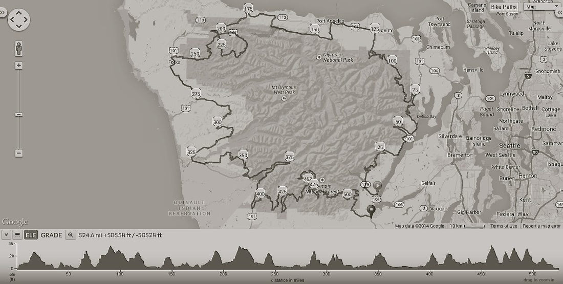

The goal is to circumnavigate Olympic National Park, staying as close as possible to the park boundary, on forest service roads and single-track trails.
We’ve been working out the logistics for weeks, leaving our sewing tables at Swift to spend evenings hunched over our maps, guides, and computers–hunting for roads that circle the Olympics. This adventure comes right on the heels of Oregon Outback for good reason: we know that the terrain and distances we are getting into will be really demanding and Outback seemed like the perfect route to flush out our gear and get inspired.
The Backstory
We’ve toured a chunk of this route on pavement two separate times, but frontage roads follow a wide circumference of the mountain range. It was beautiful, and now we want to get closer.
Until recently, bike touring was way to get somewhere on conventional roads by unconventional means.
By riding dirt roads, we’re upping the antics on adventure-times. An old friend of mine who rode the Great Divide Trail five or six years ago, well before it had captured my imagination, said that road touring wasn’t challenging enough anymore—he was craving something that took bike travel to a more demanding place. At the time I gave him an empty nod, but now I know exactly what he means.
These days the rituals of backcountry travel by bicycle are in the limelight. This time we won’t know where we pitch camp—there are few designated campgrounds en route. This time we’ll bring bear-line and a trowel. We’ll be ready for multiple days without a trace of services or electricity. And our tires will be wide.
The Route and Resources
Jason hatched this plan two or three years ago and he started digging around for anyone who had given the Olympic foothills route a shot. He hit gold when he landed on a Dual Sport Motorcycle site called Grip Twister Tours. He knew it was good when he read,
“With this tour, you will be making a loop that essentially follows the closest continuous route around Olympic National Park in Washington state, with the exception of a leg west of Port Angeles that takes the route around the north side of Crescent lake (which itself is in the National Park). This beautiful route makes the tightest loop around the park possible without back-tracking. Where one leg ends, the next leg starts. All roads are forest service or other public roads–we don’t utilize private roads, and approximately 85% of the route is unpaved… It’s back roads almost all the way, baby! Included are short side-routes that guide the rider to some of the most spectacular vistas and points of interest.”
Grip Twister Tours
The folks at Grip Twister Tours have worked on the Oly Tour route for years, honing in on the best roads, marking washouts here, and closures there. They’ve compiled a wealth of knowledge. We handed over $49.99 for the newest description of their tour, printed on waterproof paper and neatly bound. The package came with all of their GPX routes ready to load. Worth its weight in gold!
Leave No Trace ethics are echoed on every page and there’s the perfect combination of stoke and respect for the wilderness in each description. The route is broken into various legs, maps are clearly cross referenced, and–from the comfort of my living room couch–the services, camping, and roads are clearly labeled.
We’ll be following the Grip Twister route closely, but it goes without saying that there are some spots we get to modify because we’re on bike. The guide is written for a three-day motorcycle adventure, we’re thinking it will take us ten. We’ll be climbing and descending for days on end and aim to average fifty miles a day. This means that 150 miles between gas stops may be irrelevant to our adventure, but 150 miles between convenience stores is a bigger deal. Fuel is fuel. It also means that designated camping will be farther apart, but our experience of FS roads is that stealth camping is a cinch.
To bypass the minimal freeway riding that’s necessary for the route, we will ride the Olympic Discovery Trail from Sequim to Lake Crescent.
Hey, and just to say it out-loud, we’re really excited by the work that Grip Twister Tours does, so we will not post our exact route. If you’re as captivated by this tour as we are, then support these chaps by buying their guide. The spider web of roads our guides have researched goes deep, and you’ll be amazed by the research they hand you.
GPS
Yup, we’ll have our Garmin Touring Pro devices too. The guide came with the route in GPX format ready to be uploaded. For additional battery capacity we’ll carry a battery brick and Jason has a Supernova Plug installed in his headset.
Maps
We never hit the road for an extended tour without paper maps. If any of our energy sources fail then we’ll be SOL in the middle of nowhere.
Every adventurer should have the Benchmark Maps gazetteer for the area their exploring. Our Washington Road and Recreation Atlas is creased and dog eared from tons of wear. The features that set these maps apart are their inclusion of Forest Service roads, GPS coordinates, and listed amenities.
Jason puts a post-it on each atlas page that is relevant to our route, then photocopies and lays them out to link and highlight our roads. We recommend full size color copies for the best perspective. Note: scale is subject to change!
Once you have your route connected, label each map in sequence and mark relevant features like camping spots, road wash-outs, creek crossings, etc. We cross reference the Grip Twister tour book to label our maps which is time consuming but totally with the effort. Then, where possible, we cut down the map pages to reduce their size. Be careful not to cut out potential bail out roads incase you need to high tail to services.
Last thing: keep the map set protected in zip-lock bags.

Route finding and planning is one of the most exciting and time intensive parts of a trip. Especially when it’s fairly uncharted and mostly remote. It’s not time lost though, a solid route and accurate set of maps will make the trip. Mapping is a dying process as our information becomes increasingly digitized and automated, but we think there’s nothing like pouring over charts to get ready for an adventure. It’s the first step to getting out into unknown territory.
___________________________________________________________________________________
Thanks for checking out the 
For the next two weeks we’ll be getting ready to skip town. Stay tuned to find out about the route we’ll trace, the gear we’ve chosen, and how we plan to carry what we need for ten days in the mountains.
Stay tuned for Part Two
Every Bike Has a Story, Range Style: our bicycles and gear for circumnavigating the Olympic Mountain Range.
Follow the adventure
 #theRangeTour